KOENIGSHARDT (DE) - 2016-05-28 03:37:24
- Magnitude 2.8
Last update : 2016-11-24 12:52:48 Belgian time
Main parameters
| Date and time |
2016-05-28 03:37:24 UTC
2016-05-28 05:37:24 Belgian time |
| Type | Known induced event |
| Magnitude | ML 2.8 |
| Maximal intensity | III |
| Region | KOENIGSHARDT (DE) |
| Epicentral coordinates | 51.610° N, 6.890° E Uncertainty ± 4.3 km |
| Depth of hypocenter | 10.0 km |
Data source : ROB (Royal Observatory of Belgium)
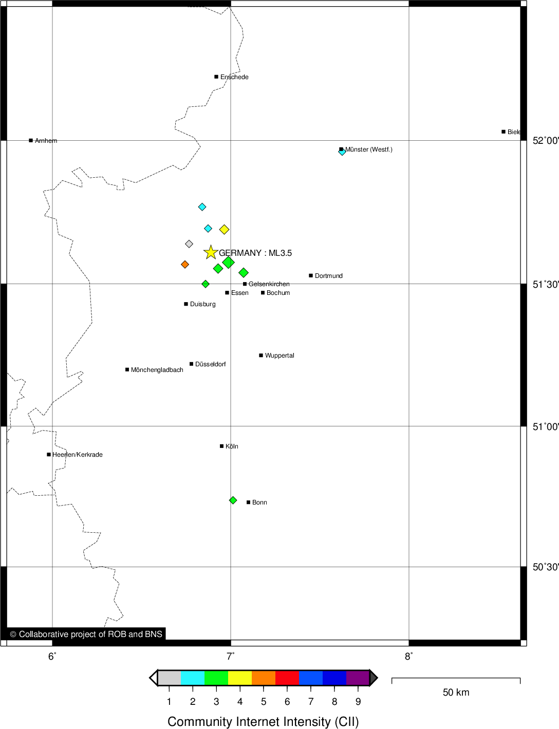
Location map
Quake measurements
Measurements by the Belgian seismic network
| Station | Epicentral distance (km) |
P-Wave arrival (hh:mm:ss.ss) | S-Wave arrival (hh:mm:ss.ss) | Maximal ground displacement (nm) |
|
|---|---|---|---|---|---|
| Code | Place | ||||
| EBN | EBEN-EMAEL | 124 | 03:37:44.79 | 03:37:59.18 | 524 |
| MEMS | MEMBACH | 127 | 03:37:44.83 | 03:38:00.13 | 538.6 |
| MOLT | MOL | 133 | 03:37:46.76 | 03:38:03.16 | - |
| LCH | LA CHARTREUSE | 141 | 03:37:47.04 | 03:38:03.87 | 270.2 |
| STI | SART TILMAN | 147 | 03:37:47.64 | - | - |
| HOU | HOUVEGNEZ | 153 | 03:37:49.12 | 03:38:06.68 | 295.8 |
| CLA | CLAVIER | 173 | 03:37:51.18 | 03:38:12.04 | 167.1 |
| KLB | KALBORN | 177 | 03:37:51.92 | 03:38:12.42 | 239.7 |
| GES | GESVES | 186 | 03:37:52.64 | 03:38:14.52 | 152.1 |
| RCH | ROCHEFORT | 200 | 03:37:55.22 | 03:38:17.69 | - |
| MRD | MAREDSOUS | 208 | 03:37:55.96 | 03:38:19.68 | 87.3 |
| UCCS | UCCLE | 198 | 03:37:56.51 | - | - |
| SNF | SENEFFE | 220 | 03:37:57.20 | 03:38:23.68 | - |
| SKQ | STEENKERQUE | 224 | 03:37:57.64 | - | - |
| RQR | RONQUIÈRES | 217 | 03:37:57.78 | - | - |
| BRQ | BRACQUEGNIES | 230 | 03:37:58.93 | - | - |
| DOU | DOURBES | 233 | 03:37:59.00 | 03:38:23.83 | 123.4 |
| LES | LESSINES | 235 | 03:37:59.06 | - | - |
| WLF | WALFERDANGE | 223 | 03:37:59.56 | 03:38:23.06 | - |
| BOU | BOUGNIES | 247 | 03:38:01.72 | - | - |
Macroseismic
Data
| Total number of responses | 17 |
|---|---|
| Intensity I | 2 |
| Intensity II | 4 |
| Intensity III | 7 |
| Intensity IV | 3 |
| Intensity V | 1 |
Attention! The intensities derived from the macroseismic enquiry are raw unverified data.
Map
Data policy
Please read on this notice to learn more about our data policy.