KOBLENZ (DE) - 2011-02-14 19:35:09
- Magnitude 2.4
Last update : 2011-06-27 18:19:24 Belgian time
Main parameters
| Date and time |
2011-02-14 19:35:09 UTC
2011-02-14 20:35:09 Belgian time |
| Type | Earthquake |
| Magnitude | ML 2.4 |
| Region | KOBLENZ (DE) |
| Epicentral coordinates | 50.348° N, 7.789° E Uncertainty ± 5.2 km |
| Depth of hypocenter | 6.8 ± 7.9 km |
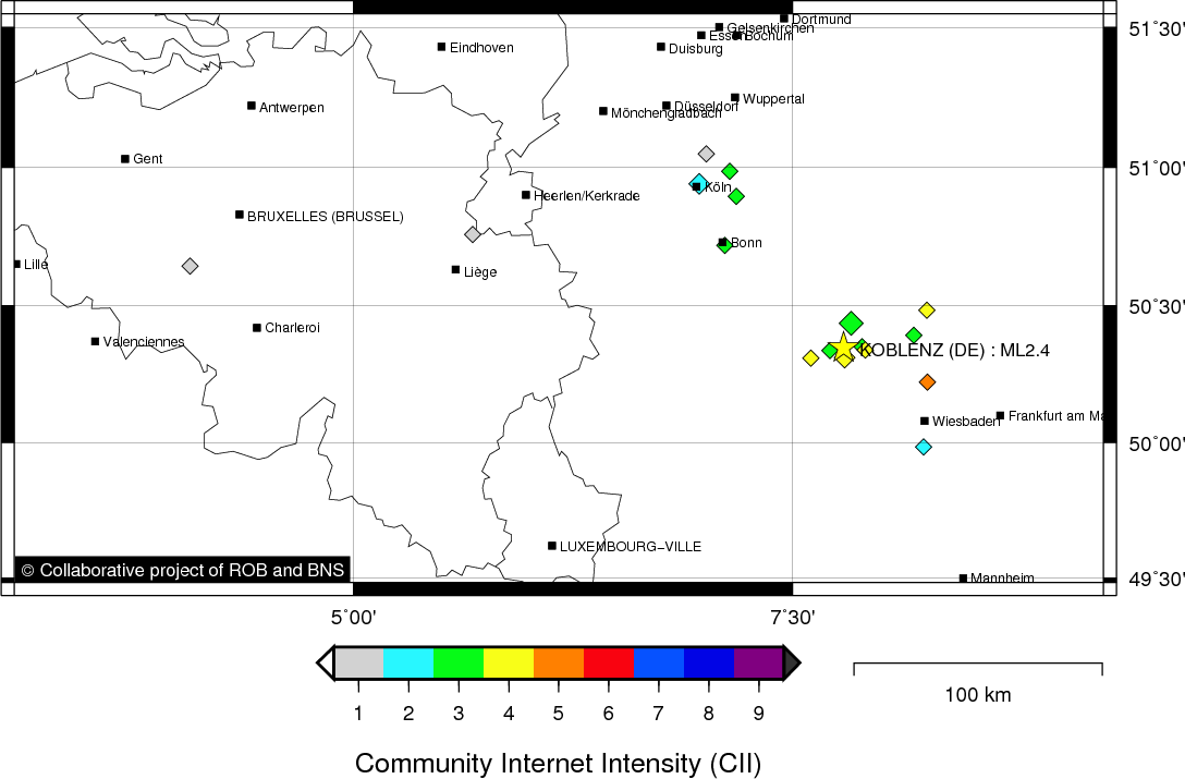
Location map
Quake measurements
Measurements by the Belgian seismic network
| Station | Epicentral distance (km) |
P-Wave arrival (hh:mm:ss.ss) | S-Wave arrival (hh:mm:ss.ss) | Maximal ground displacement (nm) |
|
|---|---|---|---|---|---|
| Code | Place | ||||
| MEMS | MEMBACH | 129 | 19:35:31.68 | 19:35:46.78 | 56.3 |
| WLF | WALFERDANGE | 140 | 19:35:32.14 | 19:35:50.54 | 51.5 |
| STI | SART TILMAN | 160 | 19:35:35.74 | - | - |
| EBN | EBEN-EMAEL | 158 | 19:35:35.82 | - | - |
| GES | GESVES | 192 | 19:35:40.16 | 19:36:01.93 | - |
| MRD | MAREDSOUS | 215 | 19:35:44.75 | - | - |
Measurements by the German seismic network of Bensberg (University of Cologne)
| Station | Epicentral distance (km) |
P-Wave arrival (hh:mm:ss.ss) | S-Wave arrival (hh:mm:ss.ss) | Maximal ground displacement (nm) |
|
|---|---|---|---|---|---|
| Code | Place | ||||
| KOE | KÖPPEL | 10 | 22:34:53.62 | 22:34:55.60 | - |
| BGG | BURG ELTZ | 36 | 22:34:57.47 | - | - |
| HOB | HOHBUSCH | 78 | 22:35:04.23 | - | - |
| HIL | HILLESHEIM | 79 | 22:35:04.63 | - | - |
| KLL | KALLTALSPERRE | 110 | 22:35:09.65 | - | - |
Macroseismic
Data
| Total number of responses | 25 |
|---|---|
| Intensity I | 5 |
| Intensity II | 4 |
| Intensity III | 11 |
| Intensity IV | 3 |
| Intensity V | 2 |
Attention! The intensities derived from the macroseismic enquiry are raw unverified data.
Map
Data policy
Please read on this notice to learn more about our data policy.