Groundwater is a hidden resource, which is quantitatively much more significant than surface waters. Their exploitation and the impacts at the surface created by groundwater withdrawals essentially for human (drinking water) and industrial needs are generally difficult to estimate, monitor and plan. It is difficult to adequately locate and quantitatively appreciate surface impacts, resulting in a lack of awareness and/or evidence regarding the extent of risks and pressures facing the growing groundwater needs. The main objectives of the LASUGEO project are associated to the groundwater exploitation that has hitherto provoked unforeseen land surface movements (subsidence sometimes followed by a non-elastic rebound during the aquifer recharge). These land surface movements need to be mapped and quantified by comparing hydrogeological models to different geodetic techniques using long time series.
The data that are necessary for achieving the different milestones of the project will be provided by
piezometric fluctuations, hydrogeological and 1D geo-mechanical models deduced from hydrogeological and
geological data, by SAR interferometry imagery, by gravity measurements and by the Belgian GNSS
stations. Several aquifers will be detailed in the framework of this project:
- the basement aquifer associated to the Paleozoic Brabant Massif (from Veurne to Brussels),
- the Tertiary aquifer systems under the central part of Flanders,
- the aquifers associated to the Pays de Herve (Liège Province) and,
- a test area where strong ground movements (subsidence) are known due to groundwater pumping activities (Jülich, Germany).
- Groundwater data compilation in the selected areas. Data required can be classified into 4 main categories: a) the geometry of the system and of the different geological formations, b) values of the hydrogeological parameters involved in the equations of the simulated processes, c) the stress factors applied to the system, d) historical data.
- Development of 3D groundwater models for water pressure calculation. The main aim is to simulate the spatial distribution of the groundwater pressures in transient conditions. Results in terms of pressure at given coupling time steps will be exchanged with the 1D geo-mechanical models for consolidation/rebound calculation in different columns located in the considered domain.
- Coupling 3D groundwater models to 1 D geo-mechanical models for consolidation and rebound calculation. The elasto-plastic laws for consolidation and elastic components for rebound can be established from classical experimental laws that need to be calibrated on the measured results.
- Sensitivity analysis to the non-linear behaviour of the hydrogeological properties. The observations-parameters-results interactions will be investigated in order to detect which processes and associated parameters are the more influent on the results.
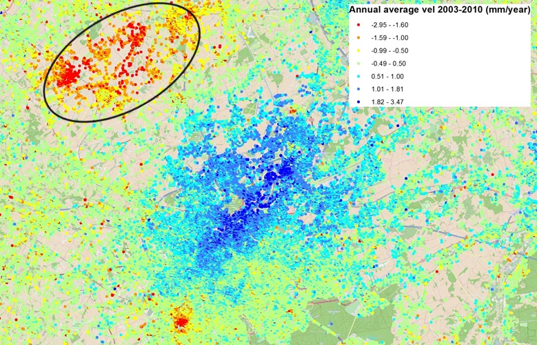
- Use of the geodetic measurements for constraining the geo-mechanical models. Long time series data based on different European radar satellites will be used and processed for historical (before 2021) and more recent acquisitions (till the year 2025) from Sentinel 1A SAR scenes. These different PSI data sets will be used to constrain the ground deformations in each ROI, to map the land subsidence bowls and to follow the land subsidence evolution through time. PSI data will be carefully compared to GNSS/GPS stations data both on a long term base by using the PS points at close proximity through time but also by using artificial corner reflectors associated to GPS stations in several sites and to extract these specific points from the newly acquired Sentinel 1A SAR imagery. Repeated absolute gravity measurements data are also collected since 1996 by the ROB and will be used as another geodetic data tool to correlate the ground deformations with SAR data, GPS stations and finally with the hydrogeological models.
- Throughout the project, each milestone will be summarised in a digital report and potentially available as an open-access document if no private restrictions are applied. Scientific publications and congresses are foreseen during the project. A dedicated conference to make the link with the stakeholders and end-users will be planned at the end of the project. Lastly, a report explaining different future scenarios on groundwater production/use and their impact at the surface estimating and predicting the potential future evolutions of these aquifers will be communicated as well.
The monitoring during several decades of the groundwater exploitation in these different types of reservoirs and their associated impacts at the surface will allow suggesting future planning use and mitigation procedures for each ROI.
The general methodology and the outputs that the consortium is intending to produce can be summarized in the 6 steps explained hereafter: